Mountain Safety for Elk Hunting: Essential Gear, Skills, and Strategies
ElkUnit StrategyGear
8 min read·Aug 4, 2026·TAGZ
Mountain Safety for Elk Hunting: Essential Gear, Skills, and Strategies

Elk country is unforgiving. High-altitude ridges, sudden weather swings, grizzly encounters, and steep drainages miles from the nearest road test every hunter who ventures into the backcountry. The best elk hunters know that safety is not paranoia or over-preparation. It is the skill set that keeps you hunting instead of dealing with a preventable crisis.

This guide walks through the core mountain safety principles every elk hunter needs, from pre-hunt preparation to emergency decision-making in the field. Whether you are chasing bulls in Colorado's high country or packing into Montana's backcountry, these strategies apply.

Pre-Hunt Physical Preparation

Elk hunting is a cardiovascular and strength test. Hunters who show up unprepared increase their injury risk and limit their ability to respond to emergencies. Start training at least eight weeks before your hunt. Focus on hiking with a weighted pack, leg strength for steep descents, and core stability for uneven terrain.

Test your gear under load before opening day. A 50-pound pack feels manageable in your driveway but crushes you at 10,000 feet after five miles. Know your limits. Pushing past exhaustion in the backcountry leads to poor decisions, twisted ankles, and worse.

If you are hunting solo, physical fitness becomes even more critical. You are your own rescue team. Train accordingly.

Navigation Tools and Skills

GPS units fail. Phones die. Fog rolls in. Every elk hunter needs multiple navigation methods and the skill to use them. Carry a handheld GPS with fresh batteries, a smartphone with offline maps, and a paper map with a compass as backup.

Before you leave the trailhead, mark key waypoints: your vehicle, camp, water sources, and planned glassing points. Study the terrain. Know which drainages lead back to the road and which dead-end into cliffs or private land.

Practice using your compass and map together. If your electronics fail three miles into a dark timber bowl, you need to know how to shoot a bearing and follow it out. Download offline maps in TAGZ or onX before your hunt. Cell service is nonexistent in most elk units.

Weather Monitoring and Layering Systems

Mountain weather changes fast. A calm September morning can turn into a whiteout by noon. Hypothermia kills hunters every season, often in conditions that seemed manageable an hour earlier.

Check extended forecasts before your hunt, but do not trust them beyond 48 hours. Carry a lightweight weather radio or satellite communicator with weather updates. Watch for cloud buildup, sudden wind shifts, and temperature drops.

Your clothing system matters more than any single piece of gear. Use a three-layer approach: a moisture-wicking base layer, an insulating mid-layer, and a windproof, waterproof shell. Avoid cotton. Wet cotton kills.

Pack extra layers even on warm days. A broken leg at 11,000 feet means you might be sitting still for hours waiting for help. What felt comfortable while hiking becomes dangerously cold when you stop moving.

Emergency Gear Every Hunter Should Carry

Your pack should include survival essentials on every hunt, regardless of how close you plan to stay to camp. At minimum, carry a first aid kit, fire starter, emergency shelter, headlamp with extra batteries, water purification, high-calorie food, and a communication device.

A satellite communicator like a Garmin inReach is worth every penny. It allows two-way texting, SOS activation, and weather updates in areas with zero cell coverage. Hunters die because they cannot call for help. Do not be one of them.

Know how to use your gear before you need it. Practice building a fire with wet wood. Set up your emergency bivy at home. Run through first aid scenarios. The middle of a crisis is not the time to figure out how your tourniquet works.
Draw odds
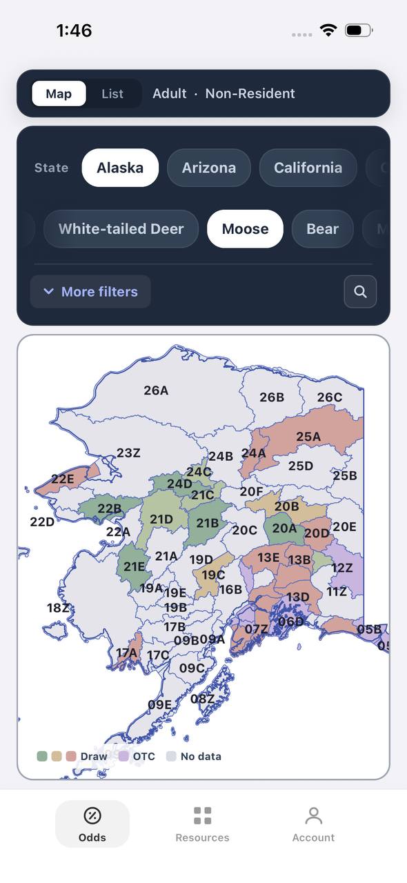
Alaska moose draw odds by unit, colored by draw, OTC, or no data
AdultNonresident

Alaska · Moose

Draw, OTC, and no-data units across the whole state.

Adult, Nonresident, Moose, no additional filters. Every unit is colored by its best matching draw odds; if nothing draws, it shows OTC; if neither, no data.

  • Alaska mixes draw and OTC moose hunts within the same region.
  • Green units are worth an application; purple units are OTC.
  • Filters stay applied when a unit is opened for hunt detail.
Draw odds
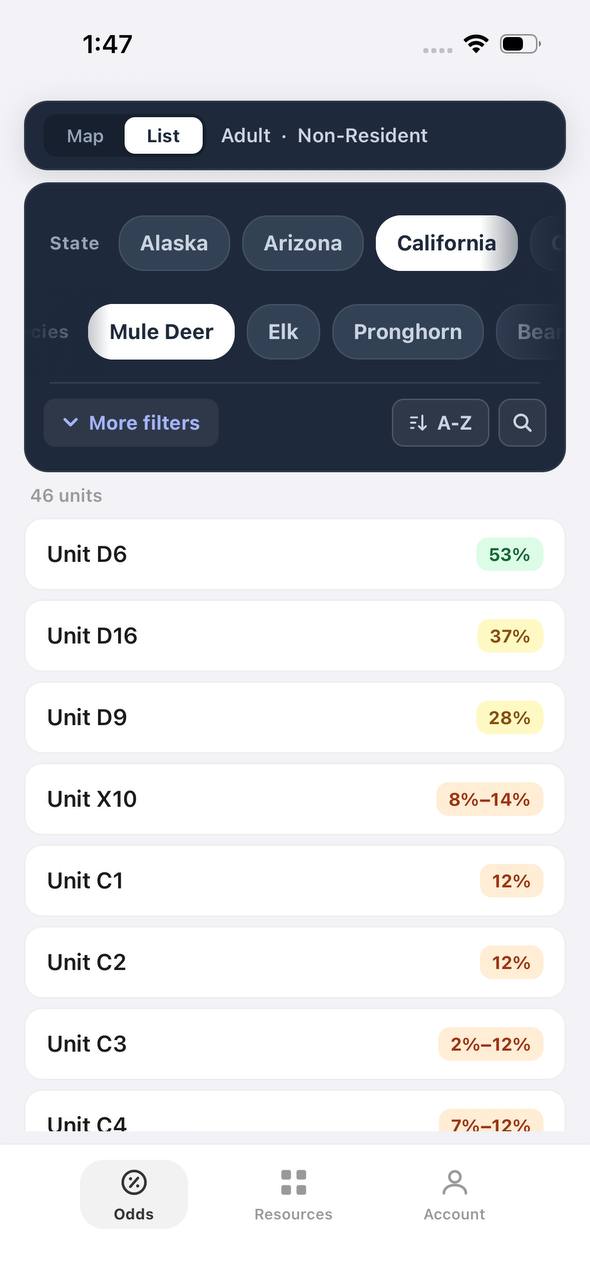
California mule deer draw odds ranked by unit in a list
AdultNonresident

California · Mule deer

Nonresident odds ranked unit by unit.

Adult, Nonresident, Mule deer, no weapon or season chip, so every matching hunt in a zone is combined into one badge and sorted by best projected odds.

  • D6 leads the list; a range like 8%–14% means more than one hunt code exists in that zone.
  • The list and the map read the same filtered hunt set.
  • 46 units are shown for this species and state alone.

Free to join

Download mobile app

  • Detailed draw odds
  • Point tracking
  • Deadline reminders
  • 18 states covered
Download on the App StoreGet it on Google Play
Unit detail
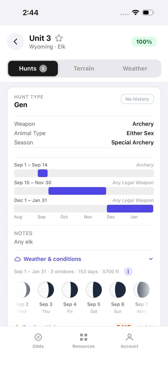
Wyoming elk unit detail, hunts tab, showing hunt windows on a timeline

Wyoming · Elk, Unit 3

Every hunt window inside one unit, laid out on a timeline.

Unit 3 has two hunt codes for elk. Each one shows its weapon, animal type, and season as a bar on a shared Aug–Jan timeline, plus a day-by-day moon phase strip.

  • Archery, then a long Any Legal Weapon window, then a late season — three opportunities in one unit.
  • The 100% badge at top means no real draw competition for the selected filters right now.
  • Weather & conditions expands below the hunt list without leaving the unit.
Terrain data
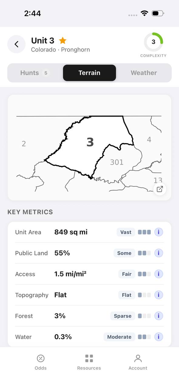
Colorado pronghorn unit detail, terrain tab, showing unit outline and key metrics

Colorado · Pronghorn, Unit 3

Unit boundaries and a complexity score at a glance.

The Terrain tab draws the unit outline against its neighbors and scores it for complexity, then breaks out area, public land, access, topography, forest, and water.

  • 849 sq mi, 55% public land, and flat topography make this a fairly approachable unit.
  • Each metric carries a short rating word — Vast, Some, Fair, Flat, Sparse, Moderate — with a tooltip.
  • The outline map shows adjacent units 2, 4, 13, and 301 for context.
State profiles
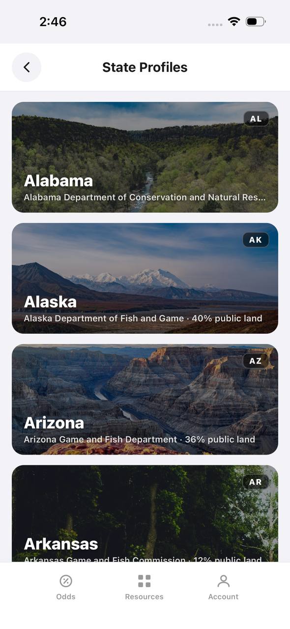
State Profiles screen listing states with wildlife agency and public land percentage

State Profiles

Each state's wildlife agency and public land share, at a glance.

State Profiles lists every covered state as a photo card naming its wildlife agency and, where available, its public land percentage.

  • Public land percentage shows right in the list, before opening the state.
  • Each card names the exact agency the regulations come from.
  • States without a public land figure yet, like Alabama here, are still listed.
Points wallet
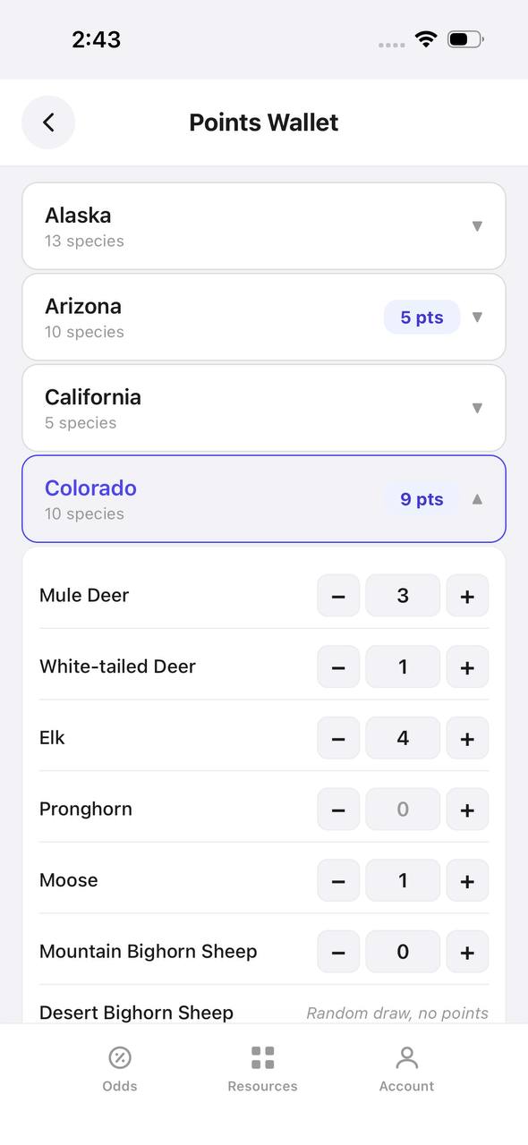
Points Wallet screen with Colorado expanded, showing a point stepper per species

Points Wallet · Colorado

Every state and species point balance in one wallet.

Points Wallet lists each state with a species count; expanding a state, like Colorado here, shows a stepper for every species so a balance can be entered or adjusted directly.

  • Colorado alone tracks points across 10 species independently.
  • Species with no points, like Pronghorn here, still show a zero to stay visible.
  • Desert Bighorn Sheep is flagged as a random draw with no points system.

Free to join

Download mobile app

  • Detailed draw odds
  • Point tracking
  • Deadline reminders
  • 18 states covered
Download on the App StoreGet it on Google Play
Draw odds
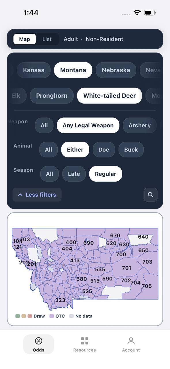
Montana white-tailed deer draw odds filtered to any legal weapon, either sex, regular season
AdultNonresidentAny Legal WeaponEitherRegular

Montana · White-tailed deer

Nearly the whole state is OTC for this filter combination.

Adult, Nonresident, White-tailed deer, filtered to Any Legal Weapon, Either, Regular. Under this combination almost every unit turns purple — over the counter.

  • Switching weapon, sex, or season changes the picture completely.
  • Purple means the tag can be bought directly, no draw.
  • This is the tag-and-go read of Montana whitetail, not the point-based one.
Terrain data
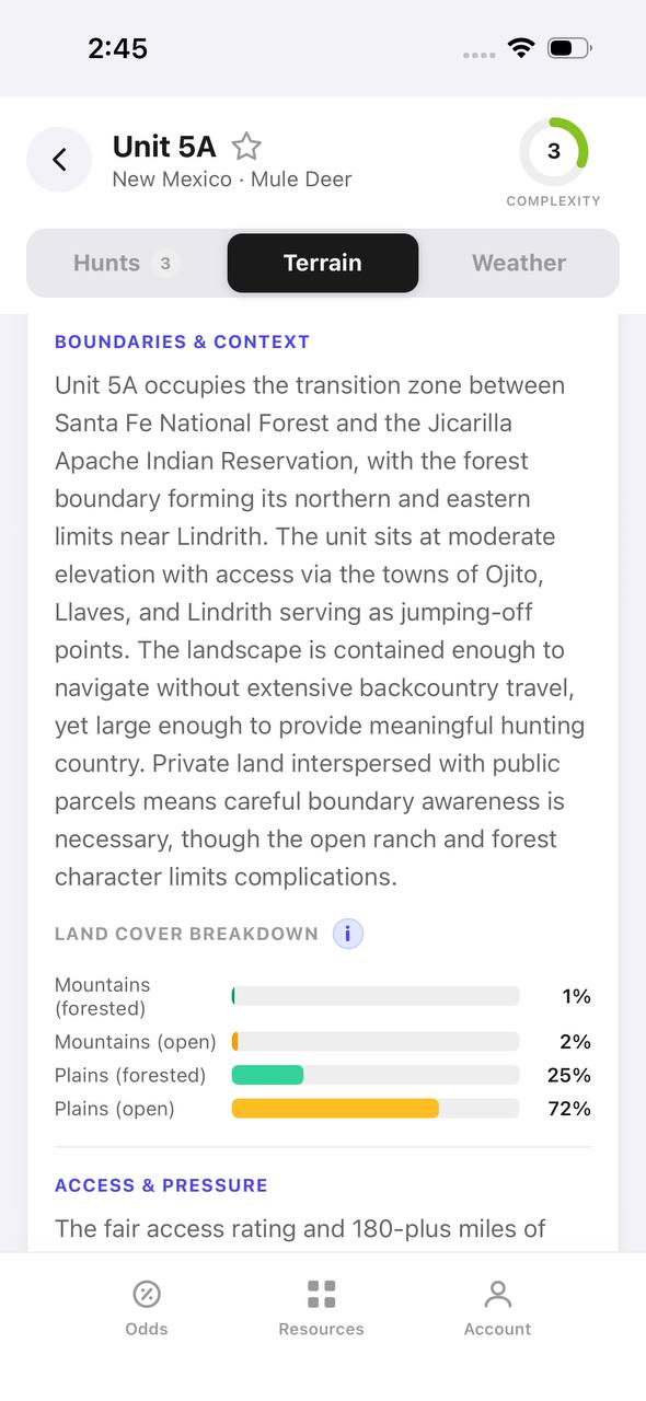
New Mexico mule deer unit 5A terrain tab with boundary description and land cover breakdown

New Mexico · Mule deer, Unit 5A

A written boundary description, not just a shape.

Unit 5A's terrain tab opens with a plain-language paragraph about surrounding land, access towns, and ownership mix, then a land cover breakdown by percentage.

  • 72% open plains and 25% forested plains describe the terrain at a glance.
  • The boundary text calls out the exact reservation and forest lines that define the unit.
  • Access & pressure continues below the fold with mileage detail.
Draw odds
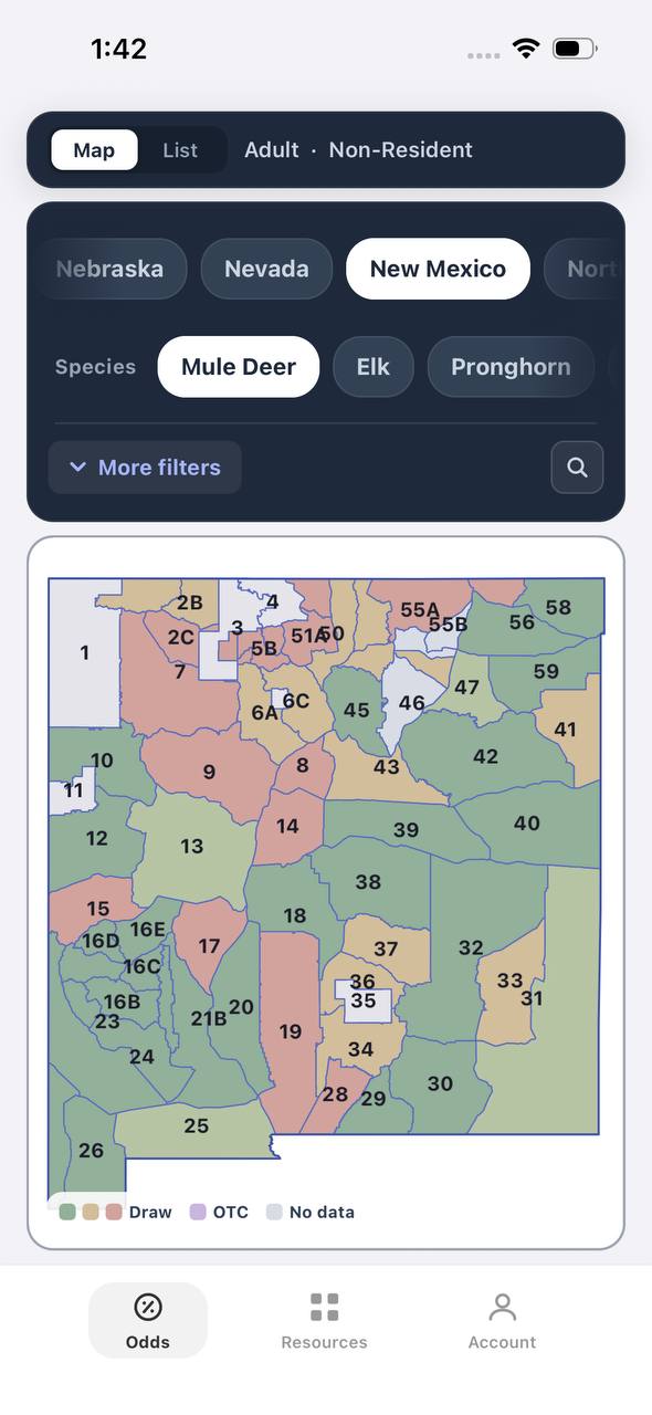
New Mexico mule deer draw odds by unit
AdultNonresident

New Mexico · Mule deer

Mule deer draw odds for every unit in the state.

Adult, Nonresident, Mule deer, all weapons and seasons. Each unit is colored by the same odds calculation used in the dashboard.

  • Green and tan together separate units worth applying to from units that are not.
  • Numbered units follow New Mexico's own game management unit boundaries.
  • Opening a unit shows the exact hunt behind the color.
Favorites
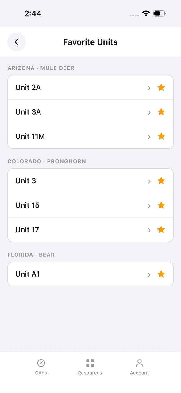
Favorite Units screen grouped by state and species

Favorite Units

Starred units from any state, grouped by species.

Favorite Units collects every starred unit across states and species into one list, grouped by state and species pair, so a saved unit is one tap away.

  • Arizona mule deer and Colorado pronghorn favorites sit side by side here.
  • Each row opens straight into that unit's detail view.
  • Unstarring from this screen removes it from the group instantly.
Deadlines
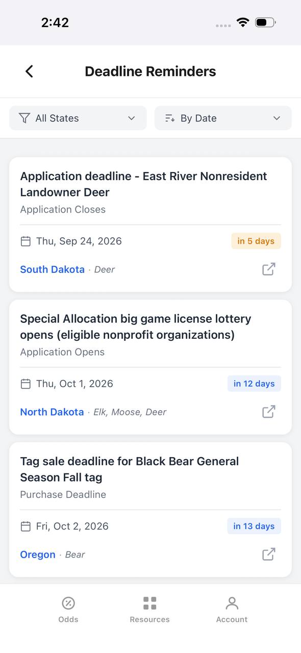
Deadline Reminders screen listing application and purchase deadlines by date

Deadline Reminders

Every application and purchase deadline, sorted by date.

Deadline Reminders filters by state and sorts by date, showing the deadline type, a countdown, and the state and species it applies to, with a link out to the source.

  • Countdown badges shift as a deadline gets close — "in 5 days" here, for example.
  • Application opens and closes are tracked as separate reminder types.
  • Each card links out to confirm the rule at the source.
Interactive map
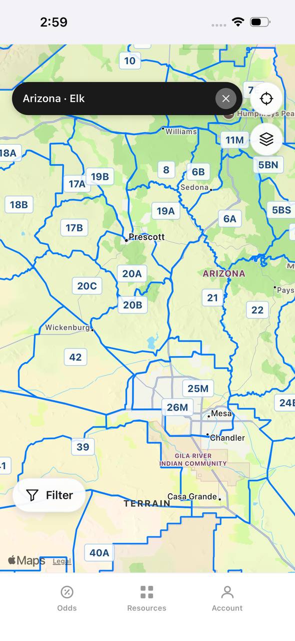
Arizona elk unit boundaries overlaid on an interactive street map

Arizona · Elk

Unit boundaries laid directly over a real map.

This view overlays Arizona elk unit boundaries and labels on top of a street map, with a search bar pinned to state and species and a layer toggle in the corner.

  • Real towns like Prescott and Sedona sit inside their unit boundaries for context.
  • A location button and layer switch float over the map, clear of the unit labels.
  • A Filter button at the bottom opens the same filters used elsewhere in the app.

Free to join

Download mobile app

  • Detailed draw odds
  • Point tracking
  • Deadline reminders
  • 18 states covered
Download on the App StoreGet it on Google Play
Insights
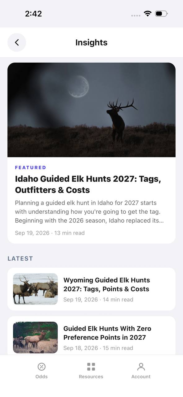
Insights screen with a featured article and a latest articles list

Insights

Hunting articles, built into the app itself.

Insights opens to a featured article with a hero image, then a Latest list of recent posts, each with a thumbnail, read time, and publish date.

  • The featured slot rotates to the newest deep-dive article.
  • Read time and publish date show on every card, not just the featured one.
  • This mirrors the blog content already published on the marketing site.
Download on the App StoreGet it on Google Play

Recognizing and Treating Altitude Sickness

Many elk units sit above 9,000 feet. Hunters coming from sea level face real altitude risks: headaches, nausea, dizziness, and in severe cases, pulmonary or cerebral edema. Altitude sickness slows your decision-making and physical performance exactly when you need both most.

Arrive a day or two early to acclimate if possible. Stay hydrated. Avoid alcohol the first night. If you develop symptoms, descend. Altitude sickness does not improve by toughing it out at elevation.

Carry aspirin or ibuprofen for headaches. Serious symptoms like confusion, difficulty breathing, or loss of coordination require immediate descent and medical attention. Know the signs before you hunt.

Bear Awareness and Encounter Protocols

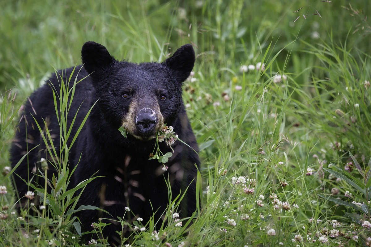
Grizzlies and black bears inhabit prime elk country across the West. Hunters field-dressing elk or packing out meat are especially vulnerable. Bear encounters happen. How you respond determines the outcome.

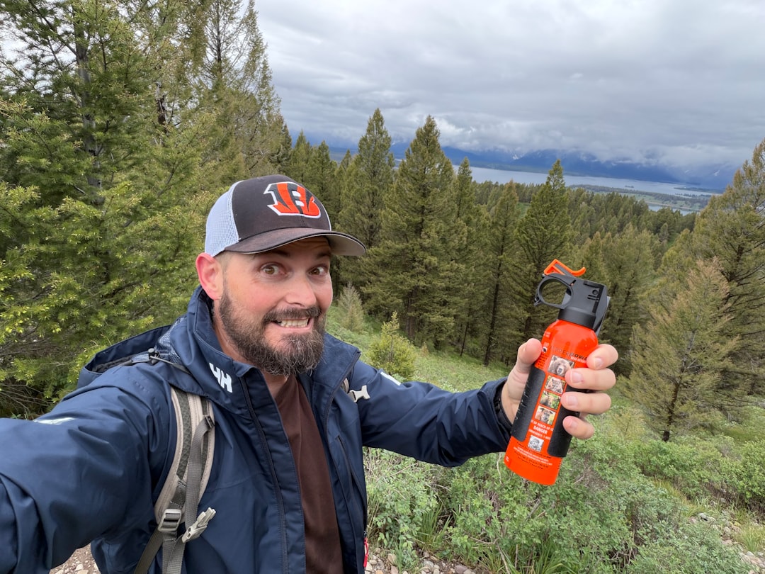
Carry bear spray in a chest holster where you can access it instantly. Know how to use it. Practice drawing and aiming without deploying. Bear spray works, but only if you can get it out before the bear closes distance.

Make noise while hiking through timber. Talk, clap, or use a bear bell. Surprise encounters are the most dangerous. If you do encounter a bear, stay calm. Do not run. Back away slowly while speaking in a calm voice. If the bear charges, deploy your spray when it reaches 30 feet.

When field-dressing an elk, work quickly and watch your surroundings. Hang or cache meat away from camp and at least 100 yards downwind. Never leave gut piles near trails or camp.

Wilderness First Aid Basics

Most backcountry injuries are not dramatic. Blisters, cuts, sprains, and dehydration cause more hunt-ending problems than bear attacks or falls. A solid first aid kit and basic medical knowledge keep small issues from becoming emergencies.

Your kit should include blister treatment, gauze, medical tape, antiseptic, pain relievers, antihistamines, a tourniquet, and any personal medications. Add a Sam splint for fractures and athletic tape for sprains.

Learn basic wound cleaning, fracture stabilization, and how to treat shock. Take a wilderness first aid course if you hunt solo or in remote units. Knowing when to self-rescue versus when to call for help is a critical skill.

Draw odds
Alaska moose draw odds by unit, colored by draw, OTC, or no data
AdultNonresident

Alaska · Moose

Draw, OTC, and no-data units across the whole state.

Adult, Nonresident, Moose, no additional filters. Every unit is colored by its best matching draw odds; if nothing draws, it shows OTC; if neither, no data.

  • Alaska mixes draw and OTC moose hunts within the same region.
  • Green units are worth an application; purple units are OTC.
  • Filters stay applied when a unit is opened for hunt detail.
Draw odds
California mule deer draw odds ranked by unit in a list
AdultNonresident

California · Mule deer

Nonresident odds ranked unit by unit.

Adult, Nonresident, Mule deer, no weapon or season chip, so every matching hunt in a zone is combined into one badge and sorted by best projected odds.

  • D6 leads the list; a range like 8%–14% means more than one hunt code exists in that zone.
  • The list and the map read the same filtered hunt set.
  • 46 units are shown for this species and state alone.

Free to join

Download mobile app

  • Detailed draw odds
  • Point tracking
  • Deadline reminders
  • 18 states covered
Download on the App StoreGet it on Google Play
Unit detail
Wyoming elk unit detail, hunts tab, showing hunt windows on a timeline

Wyoming · Elk, Unit 3

Every hunt window inside one unit, laid out on a timeline.

Unit 3 has two hunt codes for elk. Each one shows its weapon, animal type, and season as a bar on a shared Aug–Jan timeline, plus a day-by-day moon phase strip.

  • Archery, then a long Any Legal Weapon window, then a late season — three opportunities in one unit.
  • The 100% badge at top means no real draw competition for the selected filters right now.
  • Weather & conditions expands below the hunt list without leaving the unit.
Terrain data
Colorado pronghorn unit detail, terrain tab, showing unit outline and key metrics

Colorado · Pronghorn, Unit 3

Unit boundaries and a complexity score at a glance.

The Terrain tab draws the unit outline against its neighbors and scores it for complexity, then breaks out area, public land, access, topography, forest, and water.

  • 849 sq mi, 55% public land, and flat topography make this a fairly approachable unit.
  • Each metric carries a short rating word — Vast, Some, Fair, Flat, Sparse, Moderate — with a tooltip.
  • The outline map shows adjacent units 2, 4, 13, and 301 for context.
State profiles
State Profiles screen listing states with wildlife agency and public land percentage

State Profiles

Each state's wildlife agency and public land share, at a glance.

State Profiles lists every covered state as a photo card naming its wildlife agency and, where available, its public land percentage.

  • Public land percentage shows right in the list, before opening the state.
  • Each card names the exact agency the regulations come from.
  • States without a public land figure yet, like Alabama here, are still listed.
Points wallet
Points Wallet screen with Colorado expanded, showing a point stepper per species

Points Wallet · Colorado

Every state and species point balance in one wallet.

Points Wallet lists each state with a species count; expanding a state, like Colorado here, shows a stepper for every species so a balance can be entered or adjusted directly.

  • Colorado alone tracks points across 10 species independently.
  • Species with no points, like Pronghorn here, still show a zero to stay visible.
  • Desert Bighorn Sheep is flagged as a random draw with no points system.

Free to join

Download mobile app

  • Detailed draw odds
  • Point tracking
  • Deadline reminders
  • 18 states covered
Download on the App StoreGet it on Google Play
Draw odds
Montana white-tailed deer draw odds filtered to any legal weapon, either sex, regular season
AdultNonresidentAny Legal WeaponEitherRegular

Montana · White-tailed deer

Nearly the whole state is OTC for this filter combination.

Adult, Nonresident, White-tailed deer, filtered to Any Legal Weapon, Either, Regular. Under this combination almost every unit turns purple — over the counter.

  • Switching weapon, sex, or season changes the picture completely.
  • Purple means the tag can be bought directly, no draw.
  • This is the tag-and-go read of Montana whitetail, not the point-based one.
Terrain data
New Mexico mule deer unit 5A terrain tab with boundary description and land cover breakdown

New Mexico · Mule deer, Unit 5A

A written boundary description, not just a shape.

Unit 5A's terrain tab opens with a plain-language paragraph about surrounding land, access towns, and ownership mix, then a land cover breakdown by percentage.

  • 72% open plains and 25% forested plains describe the terrain at a glance.
  • The boundary text calls out the exact reservation and forest lines that define the unit.
  • Access & pressure continues below the fold with mileage detail.
Draw odds
New Mexico mule deer draw odds by unit
AdultNonresident

New Mexico · Mule deer

Mule deer draw odds for every unit in the state.

Adult, Nonresident, Mule deer, all weapons and seasons. Each unit is colored by the same odds calculation used in the dashboard.

  • Green and tan together separate units worth applying to from units that are not.
  • Numbered units follow New Mexico's own game management unit boundaries.
  • Opening a unit shows the exact hunt behind the color.
Favorites
Favorite Units screen grouped by state and species

Favorite Units

Starred units from any state, grouped by species.

Favorite Units collects every starred unit across states and species into one list, grouped by state and species pair, so a saved unit is one tap away.

  • Arizona mule deer and Colorado pronghorn favorites sit side by side here.
  • Each row opens straight into that unit's detail view.
  • Unstarring from this screen removes it from the group instantly.
Deadlines
Deadline Reminders screen listing application and purchase deadlines by date

Deadline Reminders

Every application and purchase deadline, sorted by date.

Deadline Reminders filters by state and sorts by date, showing the deadline type, a countdown, and the state and species it applies to, with a link out to the source.

  • Countdown badges shift as a deadline gets close — "in 5 days" here, for example.
  • Application opens and closes are tracked as separate reminder types.
  • Each card links out to confirm the rule at the source.
Interactive map
Arizona elk unit boundaries overlaid on an interactive street map

Arizona · Elk

Unit boundaries laid directly over a real map.

This view overlays Arizona elk unit boundaries and labels on top of a street map, with a search bar pinned to state and species and a layer toggle in the corner.

  • Real towns like Prescott and Sedona sit inside their unit boundaries for context.
  • A location button and layer switch float over the map, clear of the unit labels.
  • A Filter button at the bottom opens the same filters used elsewhere in the app.

Free to join

Download mobile app

  • Detailed draw odds
  • Point tracking
  • Deadline reminders
  • 18 states covered
Download on the App StoreGet it on Google Play
Insights
Insights screen with a featured article and a latest articles list

Insights

Hunting articles, built into the app itself.

Insights opens to a featured article with a hero image, then a Latest list of recent posts, each with a thumbnail, read time, and publish date.

  • The featured slot rotates to the newest deep-dive article.
  • Read time and publish date show on every card, not just the featured one.
  • This mirrors the blog content already published on the marketing site.
Download on the App StoreGet it on Google Play

Terrain Hazards: Cliffs, Scree, and Stream Crossings

Elk live in steep, broken country. Loose rock, hidden cliffs, and fast water create constant hazards. Slow down. Three-point contact on steep slopes. Test every handhold and foothold before committing your weight.

Scree fields are ankle-breaker traps. Cross them slowly, stepping on larger rocks when possible. If you start to slide, sit down and control your descent rather than trying to stay upright.

Stream crossings kill hunters. Cold water, slick rocks, and heavy packs are a deadly combination. Unbuckle your pack's waist and chest straps before crossing so you can dump it if you fall. Use a trekking pole for balance. If the water is thigh-deep or faster than walking speed, find another way across or wait.

Communication Plans and Check-Ins

Tell someone your plan. Provide a map with your intended route, camp location, and expected return time. Establish check-in times and stick to them. If you miss a check-in, your contact should know when to alert authorities.

If you are hunting with a partner, agree on a rally point and time if you split up. Carry a whistle for signaling. Three short blasts is the universal distress signal.

Satellite communicators allow scheduled check-ins even from deep backcountry. Set up an automated message that sends your GPS coordinates to a contact every 12 or 24 hours. It provides peace of mind and a search starting point if something goes wrong.

Draw odds
Alaska moose draw odds by unit, colored by draw, OTC, or no data
AdultNonresident

Alaska · Moose

Draw, OTC, and no-data units across the whole state.

Adult, Nonresident, Moose, no additional filters. Every unit is colored by its best matching draw odds; if nothing draws, it shows OTC; if neither, no data.

  • Alaska mixes draw and OTC moose hunts within the same region.
  • Green units are worth an application; purple units are OTC.
  • Filters stay applied when a unit is opened for hunt detail.
Draw odds
California mule deer draw odds ranked by unit in a list
AdultNonresident

California · Mule deer

Nonresident odds ranked unit by unit.

Adult, Nonresident, Mule deer, no weapon or season chip, so every matching hunt in a zone is combined into one badge and sorted by best projected odds.

  • D6 leads the list; a range like 8%–14% means more than one hunt code exists in that zone.
  • The list and the map read the same filtered hunt set.
  • 46 units are shown for this species and state alone.

Free to join

Download mobile app

  • Detailed draw odds
  • Point tracking
  • Deadline reminders
  • 18 states covered
Download on the App StoreGet it on Google Play
Unit detail
Wyoming elk unit detail, hunts tab, showing hunt windows on a timeline

Wyoming · Elk, Unit 3

Every hunt window inside one unit, laid out on a timeline.

Unit 3 has two hunt codes for elk. Each one shows its weapon, animal type, and season as a bar on a shared Aug–Jan timeline, plus a day-by-day moon phase strip.

  • Archery, then a long Any Legal Weapon window, then a late season — three opportunities in one unit.
  • The 100% badge at top means no real draw competition for the selected filters right now.
  • Weather & conditions expands below the hunt list without leaving the unit.
Terrain data
Colorado pronghorn unit detail, terrain tab, showing unit outline and key metrics

Colorado · Pronghorn, Unit 3

Unit boundaries and a complexity score at a glance.

The Terrain tab draws the unit outline against its neighbors and scores it for complexity, then breaks out area, public land, access, topography, forest, and water.

  • 849 sq mi, 55% public land, and flat topography make this a fairly approachable unit.
  • Each metric carries a short rating word — Vast, Some, Fair, Flat, Sparse, Moderate — with a tooltip.
  • The outline map shows adjacent units 2, 4, 13, and 301 for context.
State profiles
State Profiles screen listing states with wildlife agency and public land percentage

State Profiles

Each state's wildlife agency and public land share, at a glance.

State Profiles lists every covered state as a photo card naming its wildlife agency and, where available, its public land percentage.

  • Public land percentage shows right in the list, before opening the state.
  • Each card names the exact agency the regulations come from.
  • States without a public land figure yet, like Alabama here, are still listed.
Points wallet
Points Wallet screen with Colorado expanded, showing a point stepper per species

Points Wallet · Colorado

Every state and species point balance in one wallet.

Points Wallet lists each state with a species count; expanding a state, like Colorado here, shows a stepper for every species so a balance can be entered or adjusted directly.

  • Colorado alone tracks points across 10 species independently.
  • Species with no points, like Pronghorn here, still show a zero to stay visible.
  • Desert Bighorn Sheep is flagged as a random draw with no points system.

Free to join

Download mobile app

  • Detailed draw odds
  • Point tracking
  • Deadline reminders
  • 18 states covered
Download on the App StoreGet it on Google Play
Draw odds
Montana white-tailed deer draw odds filtered to any legal weapon, either sex, regular season
AdultNonresidentAny Legal WeaponEitherRegular

Montana · White-tailed deer

Nearly the whole state is OTC for this filter combination.

Adult, Nonresident, White-tailed deer, filtered to Any Legal Weapon, Either, Regular. Under this combination almost every unit turns purple — over the counter.

  • Switching weapon, sex, or season changes the picture completely.
  • Purple means the tag can be bought directly, no draw.
  • This is the tag-and-go read of Montana whitetail, not the point-based one.
Terrain data
New Mexico mule deer unit 5A terrain tab with boundary description and land cover breakdown

New Mexico · Mule deer, Unit 5A

A written boundary description, not just a shape.

Unit 5A's terrain tab opens with a plain-language paragraph about surrounding land, access towns, and ownership mix, then a land cover breakdown by percentage.

  • 72% open plains and 25% forested plains describe the terrain at a glance.
  • The boundary text calls out the exact reservation and forest lines that define the unit.
  • Access & pressure continues below the fold with mileage detail.
Draw odds
New Mexico mule deer draw odds by unit
AdultNonresident

New Mexico · Mule deer

Mule deer draw odds for every unit in the state.

Adult, Nonresident, Mule deer, all weapons and seasons. Each unit is colored by the same odds calculation used in the dashboard.

  • Green and tan together separate units worth applying to from units that are not.
  • Numbered units follow New Mexico's own game management unit boundaries.
  • Opening a unit shows the exact hunt behind the color.
Favorites
Favorite Units screen grouped by state and species

Favorite Units

Starred units from any state, grouped by species.

Favorite Units collects every starred unit across states and species into one list, grouped by state and species pair, so a saved unit is one tap away.

  • Arizona mule deer and Colorado pronghorn favorites sit side by side here.
  • Each row opens straight into that unit's detail view.
  • Unstarring from this screen removes it from the group instantly.
Deadlines
Deadline Reminders screen listing application and purchase deadlines by date

Deadline Reminders

Every application and purchase deadline, sorted by date.

Deadline Reminders filters by state and sorts by date, showing the deadline type, a countdown, and the state and species it applies to, with a link out to the source.

  • Countdown badges shift as a deadline gets close — "in 5 days" here, for example.
  • Application opens and closes are tracked as separate reminder types.
  • Each card links out to confirm the rule at the source.
Interactive map
Arizona elk unit boundaries overlaid on an interactive street map

Arizona · Elk

Unit boundaries laid directly over a real map.

This view overlays Arizona elk unit boundaries and labels on top of a street map, with a search bar pinned to state and species and a layer toggle in the corner.

  • Real towns like Prescott and Sedona sit inside their unit boundaries for context.
  • A location button and layer switch float over the map, clear of the unit labels.
  • A Filter button at the bottom opens the same filters used elsewhere in the app.

Free to join

Download mobile app

  • Detailed draw odds
  • Point tracking
  • Deadline reminders
  • 18 states covered
Download on the App StoreGet it on Google Play
Insights
Insights screen with a featured article and a latest articles list

Insights

Hunting articles, built into the app itself.

Insights opens to a featured article with a hero image, then a Latest list of recent posts, each with a thumbnail, read time, and publish date.

  • The featured slot rotates to the newest deep-dive article.
  • Read time and publish date show on every card, not just the featured one.
  • This mirrors the blog content already published on the marketing site.
Download on the App StoreGet it on Google Play

Knowing When to Turn Back

The hardest mountain safety skill is recognizing when to quit. Weather deteriorates. Injuries happen. Fatigue sets in. Hunters push through warning signs because they drove 12 hours and spent months planning. That mindset gets people killed.

If conditions turn dangerous, retreat. A blown stalk or missed opportunity is not worth your life. The mountains will be there next year.

Trust your gut. If something feels wrong, it probably is. Elk hunting is about making good decisions over and over until you succeed. One bad decision erases all the good ones.

Post-Hunt Recovery and Injury Prevention

Successful elk hunters often face their biggest physical test after the shot: packing out hundreds of pounds of meat over miles of steep terrain. This is when most injuries occur. Fatigue, celebration, and the pressure to get meat out fast lead to rushed decisions and poor technique.

Pace yourself. Break the packout into multiple trips if needed. Use proper lifting technique: bend your knees, keep the load close to your body, and avoid twisting your spine. Trekking poles reduce knee stress on descents.

Stay hydrated and eat regularly. Your body is burning massive calories. Dehydration and low blood sugar impair judgment and coordination. Take breaks. Pushing through exhaustion when carrying heavy loads is how hunters fall, blow out knees, or suffer heart attacks.

FAQ — Mountain Elk Hunting Safety

What is the most important safety gear for backcountry elk hunting?

A satellite communicator. It allows you to call for help, send your GPS location, and receive weather updates in areas without cell service. Everything else is secondary to the ability to communicate in an emergency.

How do I prepare physically for high-altitude elk hunting?

Start training eight weeks out with weighted pack hikes, focusing on leg strength and cardiovascular endurance. Arrive at elevation a day or two early to acclimate, stay hydrated, and avoid alcohol the first night. Altitude sickness is serious and requires descent if symptoms develop.

What should I do if I encounter a grizzly bear while elk hunting?

Stay calm and do not run. Back away slowly while speaking in a calm voice. If the bear charges, deploy bear spray when it reaches 30 feet. Carry spray in a chest holster where you can access it instantly. Make noise while hiking to avoid surprise encounters.

How often should I check in with someone during a backcountry hunt?

Establish a check-in schedule before you leave, typically every 12 to 24 hours. Use a satellite communicator to send GPS coordinates and status updates. If you miss a check-in, your contact should know when to alert authorities.

What are the signs of hypothermia, and how do I treat it?

Early signs include shivering, confusion, slurred speech, and loss of coordination. Get the person dry, add layers, provide warm liquids, and seek shelter. If symptoms worsen to severe shivering, drowsiness, or unconsciousness, this is life-threatening and requires immediate evacuation and medical help.

When should I turn back instead of continuing a hunt?

Turn back when weather deteriorates beyond safe conditions, you are injured or exhausted to the point of poor decision-making, or your gut tells you something is wrong. No elk is worth your life. The mountains will be there next season.

Continue Planning Your Hunt

Mountain safety is not just about surviving emergencies. It is about making smarter decisions before, during, and after your hunt. TAGZ helps you research units with terrain maps, elevation profiles, and public land boundaries so you can plan safer access routes and understand the country before you step into it.

Compare units side by side to evaluate terrain difficulty, remoteness, and access points. Track your preference points and bonus points across multiple states so you can target hunts that match your fitness level and experience. Whether you are planning an OTC Colorado elk hunt or applying for a limited-entry Montana tag, TAGZ gives you the tools to make informed decisions from application season through your packout.

Explore unit maps, historical draw data, and hunt planning resources at TAGZ Insights. Create a free account to start building your hunt strategy at TAGZ Product, or check out our Pricing to unlock advanced features. Visit the TAGZ homepage to see how we help hunters make smarter decisions in the field.