How to E-Scout for Elk: A Realistic Approach for Western Hunters
ElkScoutingUnit Strategy
3 min read·May 28, 2026
How to E-Scout for Elk: A Realistic Approach for Western Hunters

E-scouting for elk means doing your homework before you ever step foot in the mountains. It’s about using digital tools to find likely elk habitat, figure out access, and make a plan. But there’s more to it than just dropping pins on a map. Here’s how experienced western hunters break it down.

Reading the Terrain: It’s More Than Just Contour Lines

Maps are where it all starts. Topo maps, satellite imagery, and even hunt unit overlays tell you where the elk could be — but you have to read between the lines.

  • Elevation: Elk follow the food and cover. Early season, look higher. As pressure mounts, or in late season, focus lower elevations with cover and feed.
  • North vs. South Slopes: North-facing slopes hold snow and stay greener longer, making them prime bedding areas. South slopes green up first in spring but dry out fast.
  • Water Sources: Mark springs, creeks, and wallows. Water is non-negotiable, especially in dry years.
  • Edge Habitat: Elk like transition zones — where timber meets meadows or burns meet thick cover. These edges are feeding and travel corridors.

I spend hours toggling between satellite and topo, looking for benches, saddles, and hidden pockets where elk can feed or bed with some security.

Access, Pressure, and Realistic Expectations

Finding elk is one thing. Getting to them — and not having twenty trucks at the trailhead — is another.

  • Trailheads and Roads: Mark every access point. If it’s easy for you, it’s easy for everyone. The farther you get from roads, the less competition you’ll likely see.
  • Private vs. Public: Use land ownership overlays. Some of the best elk spots are landlocked or require careful navigation along boundaries.
  • Pressure Hotspots: Look for obvious glassing knobs or basins with well-worn trails — these are hunter magnets. I always try to find at least one backup area that’s harder to reach or overlooked.

Remember, elk are masters at avoiding pressure. If you can find a pocket that’s tough to reach or just a little out of the way, odds are better you’ll find elk there during rifle or archery seasons.

Scouting Behavior and Adapting Your Plan

No e-scout plan survives first contact with the mountains. But the more you know ahead of time, the less you’re scrambling on day one.

  • Glassing Spots: Mark ridgelines or points where you can see into basins or meadows.
  • Travel Corridors: Identify possible routes elk use to move from bedding to feeding or water, especially funnels and saddles.
  • Plan B, C, and D: Pressure, weather, or a surprise wildfire can change everything. Have alternate spots picked out — it saves you time and frustration.

How TAGZ Makes E-Scouting Simpler

TAGZ combines map layers, draw odds, and unit info in one spot. Instead of jumping between apps and spreadsheets, you can compare terrain, pressure, and access for every western elk unit. It’s a time-saver, especially when you’re juggling scouting with work and family.

When you’re ready to get serious about your hunt, TAGZ helps you cut through the noise and dial in your plan.
Draw odds
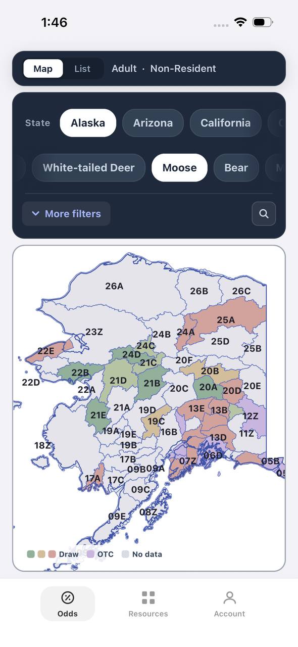
Alaska moose draw odds by unit, colored by draw, OTC, or no data
AdultNonresident

Alaska · Moose

Draw, OTC, and no-data units across the whole state.

Adult, Nonresident, Moose, no additional filters. Every unit is colored by its best matching draw odds; if nothing draws, it shows OTC; if neither, no data.

  • Alaska mixes draw and OTC moose hunts within the same region.
  • Green units are worth an application; purple units are OTC.
  • Filters stay applied when a unit is opened for hunt detail.
Draw odds
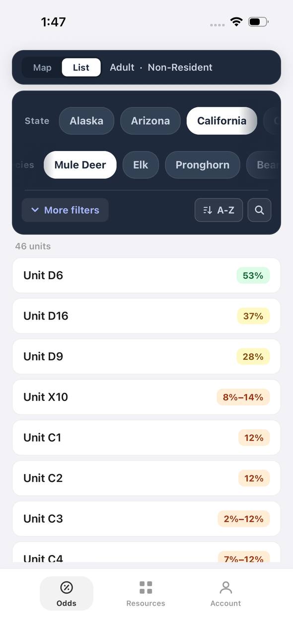
California mule deer draw odds ranked by unit in a list
AdultNonresident

California · Mule deer

Nonresident odds ranked unit by unit.

Adult, Nonresident, Mule deer, no weapon or season chip, so every matching hunt in a zone is combined into one badge and sorted by best projected odds.

  • D6 leads the list; a range like 8%–14% means more than one hunt code exists in that zone.
  • The list and the map read the same filtered hunt set.
  • 46 units are shown for this species and state alone.

Free to join

Download mobile app

  • Detailed draw odds
  • Point tracking
  • Deadline reminders
  • 18 states covered
Download on the App StoreGet it on Google Play
Unit detail
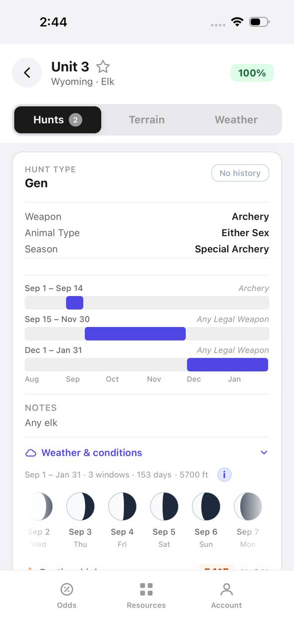
Wyoming elk unit detail, hunts tab, showing hunt windows on a timeline

Wyoming · Elk, Unit 3

Every hunt window inside one unit, laid out on a timeline.

Unit 3 has two hunt codes for elk. Each one shows its weapon, animal type, and season as a bar on a shared Aug–Jan timeline, plus a day-by-day moon phase strip.

  • Archery, then a long Any Legal Weapon window, then a late season — three opportunities in one unit.
  • The 100% badge at top means no real draw competition for the selected filters right now.
  • Weather & conditions expands below the hunt list without leaving the unit.
Terrain data
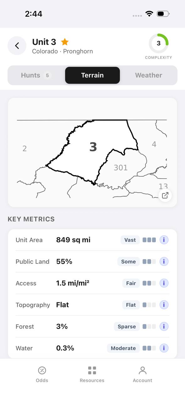
Colorado pronghorn unit detail, terrain tab, showing unit outline and key metrics

Colorado · Pronghorn, Unit 3

Unit boundaries and a complexity score at a glance.

The Terrain tab draws the unit outline against its neighbors and scores it for complexity, then breaks out area, public land, access, topography, forest, and water.

  • 849 sq mi, 55% public land, and flat topography make this a fairly approachable unit.
  • Each metric carries a short rating word — Vast, Some, Fair, Flat, Sparse, Moderate — with a tooltip.
  • The outline map shows adjacent units 2, 4, 13, and 301 for context.
State profiles
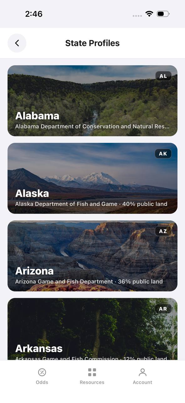
State Profiles screen listing states with wildlife agency and public land percentage

State Profiles

Each state's wildlife agency and public land share, at a glance.

State Profiles lists every covered state as a photo card naming its wildlife agency and, where available, its public land percentage.

  • Public land percentage shows right in the list, before opening the state.
  • Each card names the exact agency the regulations come from.
  • States without a public land figure yet, like Alabama here, are still listed.
Points wallet
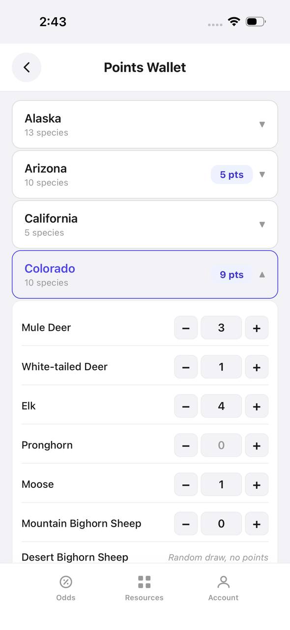
Points Wallet screen with Colorado expanded, showing a point stepper per species

Points Wallet · Colorado

Every state and species point balance in one wallet.

Points Wallet lists each state with a species count; expanding a state, like Colorado here, shows a stepper for every species so a balance can be entered or adjusted directly.

  • Colorado alone tracks points across 10 species independently.
  • Species with no points, like Pronghorn here, still show a zero to stay visible.
  • Desert Bighorn Sheep is flagged as a random draw with no points system.

Free to join

Download mobile app

  • Detailed draw odds
  • Point tracking
  • Deadline reminders
  • 18 states covered
Download on the App StoreGet it on Google Play
Draw odds
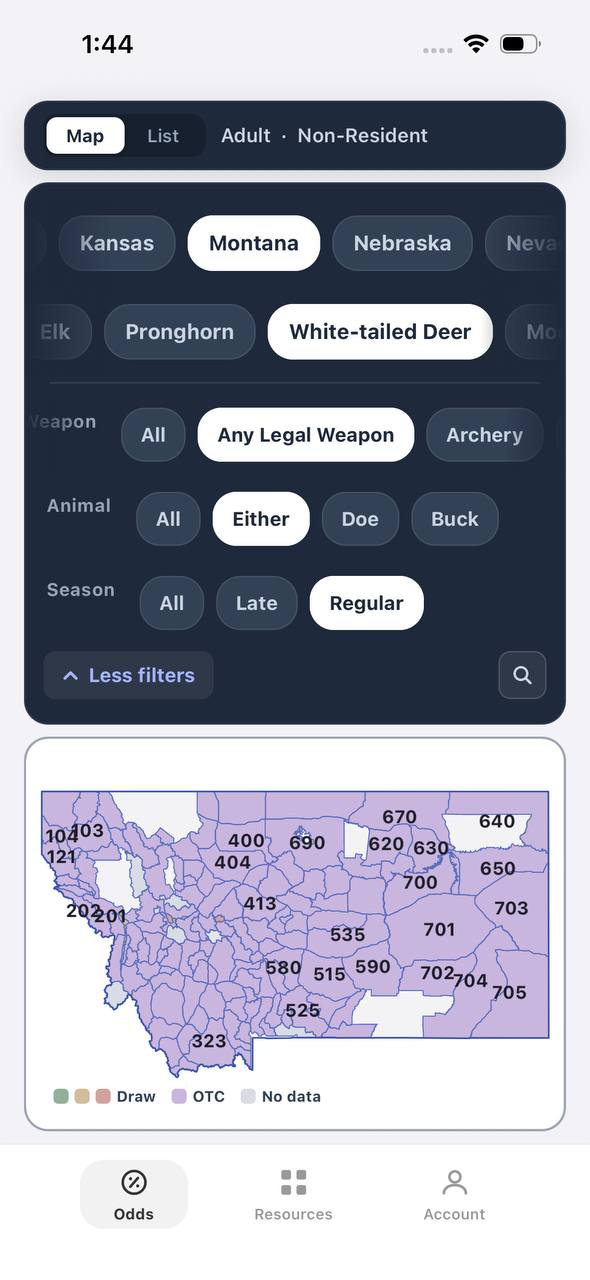
Montana white-tailed deer draw odds filtered to any legal weapon, either sex, regular season
AdultNonresidentAny Legal WeaponEitherRegular

Montana · White-tailed deer

Nearly the whole state is OTC for this filter combination.

Adult, Nonresident, White-tailed deer, filtered to Any Legal Weapon, Either, Regular. Under this combination almost every unit turns purple — over the counter.

  • Switching weapon, sex, or season changes the picture completely.
  • Purple means the tag can be bought directly, no draw.
  • This is the tag-and-go read of Montana whitetail, not the point-based one.
Terrain data
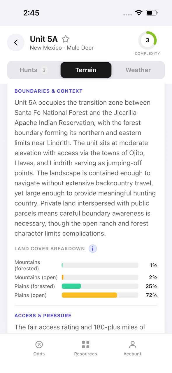
New Mexico mule deer unit 5A terrain tab with boundary description and land cover breakdown

New Mexico · Mule deer, Unit 5A

A written boundary description, not just a shape.

Unit 5A's terrain tab opens with a plain-language paragraph about surrounding land, access towns, and ownership mix, then a land cover breakdown by percentage.

  • 72% open plains and 25% forested plains describe the terrain at a glance.
  • The boundary text calls out the exact reservation and forest lines that define the unit.
  • Access & pressure continues below the fold with mileage detail.
Draw odds
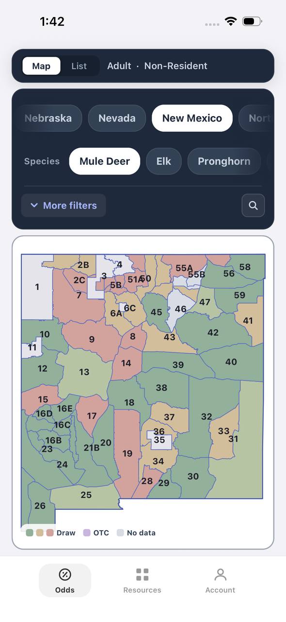
New Mexico mule deer draw odds by unit
AdultNonresident

New Mexico · Mule deer

Mule deer draw odds for every unit in the state.

Adult, Nonresident, Mule deer, all weapons and seasons. Each unit is colored by the same odds calculation used in the dashboard.

  • Green and tan together separate units worth applying to from units that are not.
  • Numbered units follow New Mexico's own game management unit boundaries.
  • Opening a unit shows the exact hunt behind the color.
Favorites
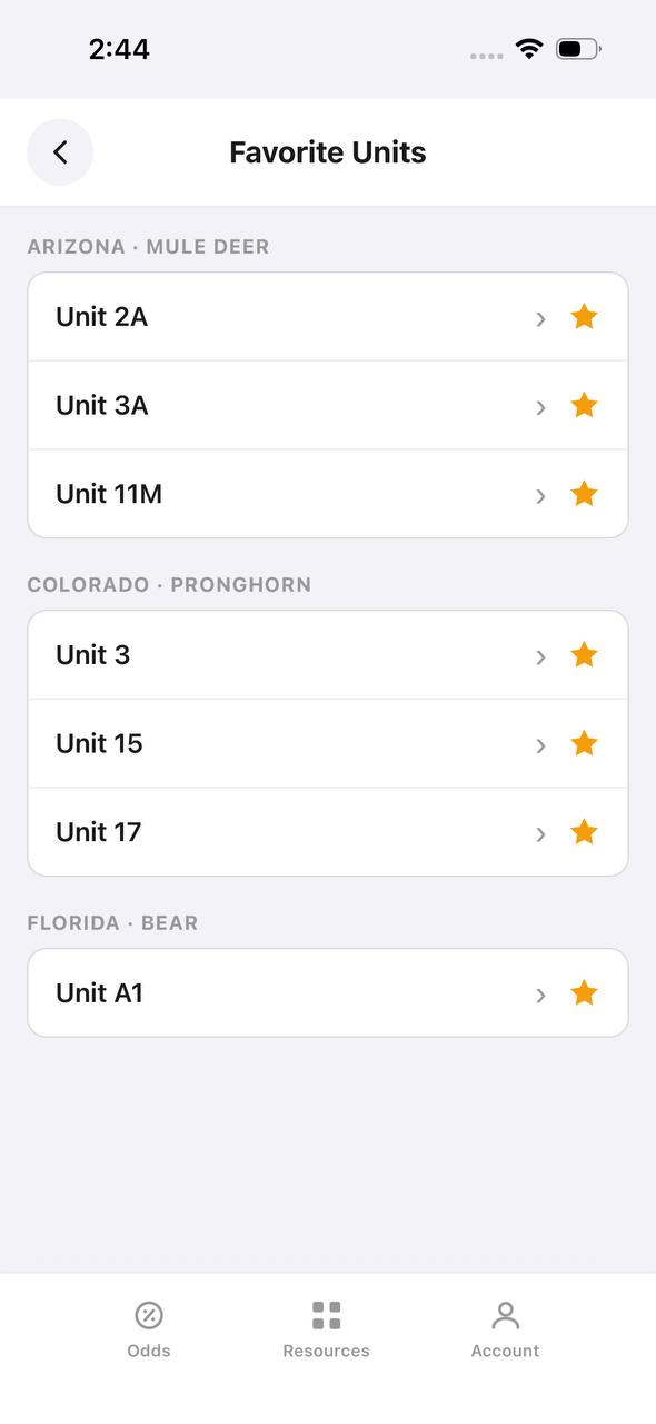
Favorite Units screen grouped by state and species

Favorite Units

Starred units from any state, grouped by species.

Favorite Units collects every starred unit across states and species into one list, grouped by state and species pair, so a saved unit is one tap away.

  • Arizona mule deer and Colorado pronghorn favorites sit side by side here.
  • Each row opens straight into that unit's detail view.
  • Unstarring from this screen removes it from the group instantly.
Deadlines
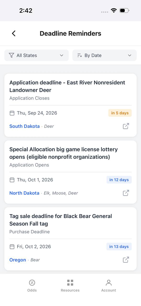
Deadline Reminders screen listing application and purchase deadlines by date

Deadline Reminders

Every application and purchase deadline, sorted by date.

Deadline Reminders filters by state and sorts by date, showing the deadline type, a countdown, and the state and species it applies to, with a link out to the source.

  • Countdown badges shift as a deadline gets close — "in 5 days" here, for example.
  • Application opens and closes are tracked as separate reminder types.
  • Each card links out to confirm the rule at the source.
Interactive map
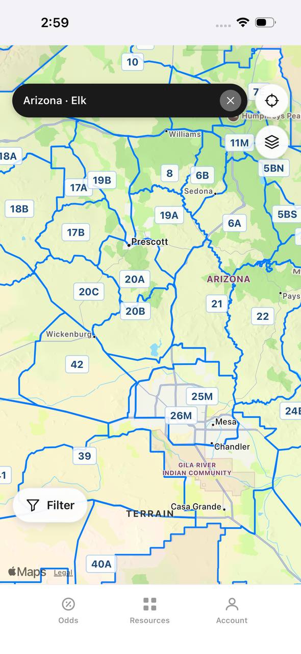
Arizona elk unit boundaries overlaid on an interactive street map

Arizona · Elk

Unit boundaries laid directly over a real map.

This view overlays Arizona elk unit boundaries and labels on top of a street map, with a search bar pinned to state and species and a layer toggle in the corner.

  • Real towns like Prescott and Sedona sit inside their unit boundaries for context.
  • A location button and layer switch float over the map, clear of the unit labels.
  • A Filter button at the bottom opens the same filters used elsewhere in the app.

Free to join

Download mobile app

  • Detailed draw odds
  • Point tracking
  • Deadline reminders
  • 18 states covered
Download on the App StoreGet it on Google Play
Insights
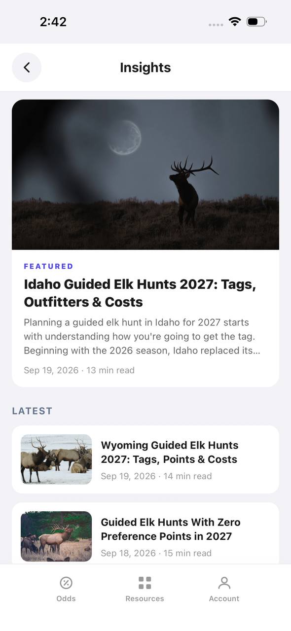
Insights screen with a featured article and a latest articles list

Insights

Hunting articles, built into the app itself.

Insights opens to a featured article with a hero image, then a Latest list of recent posts, each with a thumbnail, read time, and publish date.

  • The featured slot rotates to the newest deep-dive article.
  • Read time and publish date show on every card, not just the featured one.
  • This mirrors the blog content already published on the marketing site.
Download on the App StoreGet it on Google Play

FAQ: E-Scouting for Elk

Q: How far from the road should I look for elk?
A: There’s no magic number, but elk often move a mile or more from roads under pressure. Focus on terrain features that discourage lazy hunters.

Q: Can I trust map data for water and trails?
A: Use it as a guide, but verify with recent satellite images and trip reports. Springs dry up, and trails fade.

Q: Is e-scouting enough, or do I need boots-on-the-ground scouting too?
A: E-scouting is a huge advantage, but nothing beats firsthand scouting if you can swing it.